


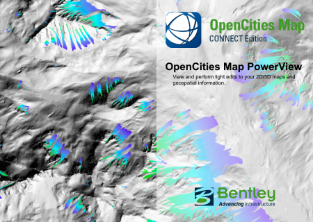
OpenCities Map PowerView CONNECT Edition Update 16
OpenCities Map PowerView CONNECT Edition Update 16 | 3.6 Gb
The software developer OpenCities Map is pleased to announce the availability of OpenCities Map PowerView CONNECT Edition Update 16 (10.16.00.60). This software enables you to view map assets and perform light 2D feature acquisition and editing.
OpenCities Map CONNECT Edition Update 16 Release notes
Bentley is pleased to announce OpenCities Map CONNECT Edition Update 16, a new release of OpenCities Map products to provide 2D / 3D Desktop GIS and Mapping, is available for immediate download. All three editions – OpenCities Map PowerView, OpenCities Map Advanced, and OpenCities Map Ultimate, and the OpenCities Map Advanced SDK have been released.
Note: that the Update number has been adjusted to coincide with the Power Platform / MicroStation Update number, there were no updates between 7.1 and 16.
New Features and Capabilities
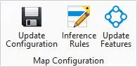
New Map Configuration Ribbon Group: These tools are designed to elevate your File-based CAD designs to Geospatial data models using geospatial schemas and geospatial databases.
OpenCities Map PowerView CONNECT Edition Update 16

Update Configuration: This tool will update the active configuration (Workspace/Workset), and make sure that it is fully compatible with OpenCities Map. If required, a new blank OpenCities Map schema will be created.
Inference Rules: This new command remains in the Technology Preview set of features, and allows you to create feature definitions for the inferred features in the active session. The New Live Feature Detection Rules dialog is like MicroStation’s Display Rules dialog. You use an editor to specify conditions in-which the elements are to be inferred as features in the Map Schema. It is also possible with the rules to set property values for the inferred feature based on information extracted from the CAD element. Conditions can be added and or combined to ensure the Features meet your Schema specifications.
Update Features: A simplified workflow to update feature definitions in an OpenCities Map schema and update the active configuration (Workspace/Workset).
414109 Data Browser would not recognize Properties from Spatial databases, from a Select Set
414900 Zoom Scale did not update when Features were not in the View
416022 Fixed the MS_GEOIMPORT_PATH variable
474690 Fixed the Text Priority issue where default value of -5,500 was set in Annotation
793768 Added a variable to define the Spatial Location for Data Export
923437 Map Mobile Publisher and the Data Browser now use the Edit Column in combo boxes
934820 Fixed Tool Box and Task Navigation errors when icons were missing
977509 Fixed the menu bar in the Geospatial Administrator (GSA) for foreign languages
1033771 Fixed a problem when a String with a comma errored when saving to .csv file
1054304 Fixed the Latitude/Longitude display in the Auxillary Coordinate Readout pane
1061781 Text was not scaling correctly when changing Drawing Scale
1072323 Spatial Unlock was incorrectly reporting that Features failed to lock
1013571 ArcGIS Connect dialog box needed resizing for the Server URL label
1111905 Provided the option to select a default favorite template with the MS_GEOPRINTPREP_FAVORITE variable Preparation
1113591 Fixed an issue when defining multiple spatial view in the GSA
1114632 Added the capability to create DB Properties when using DB Linkages
1115231 Fixed a Post issue where the spatial table without a value for the CLOB column fails
1115472 Made the "Update Command Manager List" command automatic
1119187 Replaced the Admin Workflow from MicroStation in the Map products
1119237 Fixed an issue when ArcGIS returned double.NaN for a missing Z ordinate
1121769 Now allowing more than one Place by Command Keyin method
1121789 Technology Preview items are now installed by default in the Configure page
1122202 Fixed the issue were the Layers would become 'unknown' after closing DGN File
1123497 Style and Scale are not considered for Text Features, and have been removed from XFM and Export to Schema
1123823 Import Shapefile was failing when Fence or View spatial extent was used
1124426 Fixed an issue with a specific dataset where Query a specific feature got caught in a loop
1124869 Updated the GSA for Workset and Workspace where Project was used
1126301 Load By Selection to the Data Browser for spatial databases has been fixed
1126309 Using an ad hoc connection the data browser returns an error when using a where clause
1126319 Correctly translated the Connect tab for an ArcGIS Connection
1126320 Correctly translated the User and Service Name for an Oracle Connection
1126743 Fixed a memory leak attaching a specific Cell Library
1126859 Fixed the symbology dialog where point-text features would allow zero or neg scale
1126909 Fixed a WFS Connection issue where a query would complete, but return no features
1127013 Fixed the ArcGIS Server connection where some URLS would cause Exceptions and report "Invalid URL Code:400" and "Token Required"
1127356 Fixed Add/Insert Rows for Domain List values
1127376 Made the Create New Workset and Edit Workset Parameters dialogs resizable
1127893 Fixed an issue where VBA was failing with a Print Preparation object
1127893 Fixed an invalid geometries problem with a specific ArcGIS connection
1128040 Fixed a Query issue when clicking info about a previously attached coordinate system
1128591 Fixed an issue in the Data Browser when an attribute is named FKT in a Domain List
1128592 Fixed an issue in the Data Browser when attributes were defined as numeric, displayed with decimal places
1128593 Data Browser will no longer display MSLINK when it is defined as a Primary Key
1128595 Attributes for WM_VALID (startdate, enddate) is now displayed.
1128596 Removed the limit for Domain List entries in the Data Browser
1128599 Fixed a Fill problem converting from DGN to DWG in OpenCities Map For Finland
1128673 Fixed Query WFS by Fence or View with EPSG:26916
1129741 Annotation sub-feature was moved during posting to the database
1129850 Replaced the GEOZONE MDL so that it will install with the CONNECT Editions
1129915 Fixed an Unrecognized property type dateTime error
1130028 Fixed an issue where Spatial Query by Fence created from an element in a reference that had a Global Origin not set to 0,0,0 produced an error
1130045 Fixed an issue were DGN2DB would create an incomplete .DAT file
1130162 Corrected some typos in the messages during Import / Export
1130811 Fixed the Overwrite Placement Method to update operation dialog boxes
1130893 Fixed a problem when Line Features also included a line-string Element
1130940 Fixed the line break problem "\010" when followed by a number
1130964 Cleaned-up the code in Map Manager/Print Preparation
1131061 Updated the GeoECSDK's postgres client
1131135 Corrected an Export issue in the new Export Feature Definitions code
1131442 Renamed the tools in the Feature Inference Group (from Tech Preview names)
1131454 Corrected an issue where a Feature in a Reference would not add to a Selection Set
1131595 Corrected a File Close issues for Session Feature lists
1131601 Corrected a problem in the GSA where the Path was not being updated
1131869 Fixed an Exception issue that occurred when you clicked on the Graphical Source a second time
1132120 Added the subfolder 'vue' to the .exe.config files for all Map editions
1132346 Cleaned-up some code where the Print Frame Selection was not clearly arranged
1132385 Renamed the tools in the Technology Preview list
1132837 Fixed a problem where the Polygon Collection area pattern cell color was not right
1133082 Updated the Help document for the MS_GEOIMPORT_PATH and MS_GEOEXPORT_PATH variables
1134256 Cleaned-up the code that caused an exception during model change event
1134720 Corrected a problem in ArcGIS ad hoc connections that do not require username or password
OpenCities Map PowerView CONNECT Edition Update 16

OpenCities Map , an innovative geospatial platform made specifically for MicroStation users. OpenCities Map is built right on top of MicroStation and has a familiar user interface that makes it easy to quickly become proficient in creating powerful GIS models. For Bentley MicroStation users, OpenCities Map is the best way to modernize your existing CAD environment and tap into the power of spatially fueled GIS workflows. It’s easy to use and integrates powerful GIS tools into the MicroStation interface you rely on every day.
OpenCities Map PowerView enables you to view map assets and perform light 2D feature acquisition and editing. It supports GPS and editing capabilities, making it ideal for field-based operations that require feature editing. OpenCities Map PowerView enables direct querying of and imports from leading spatial databases such as Oracle Spatial, Microsoft SQL Server, Esri File Geodatabase, ArcGIS Server & Online, PostgreSQL (PostGIS) and Web Feature Service (WFS), providing you with seamless and intuitive access to spatial data from a variety of sources. Moreover, the application comes with the same (API) as OpenCities Map Advanced and OpenCities Map Ultimate. Therefore, it is possible to use OpenCities Map PowerView as a platform to run custom GIS applications developed with OpenCities Map Advanced or OpenCities Map Ultimate.
Bentley OpenCities Map
Bentley Systems, Incorporated is the global leader dedicated to providing architects, engineers, constructors, and owner-operators with comprehensive architecture and engineering software solutions for sustaining infrastructure. Founded in 1984, Bentley has nearly 3,000 colleagues in more than 45 countries, $500 million in annual revenues, and, since 2001, has invested more than $1 billion in research, development, and acquisitions.
Product: OpenCities Map PowerView
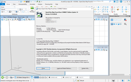
Version: CONNECT Edition Update 16 (10.16.00.60)
Supported Architectures: x64
Website Home Page : www.bentley.com
Languages Supported: english
System Requirements: PC *
Size: 3.6 Gb
OpenCities Map PowerView CONNECT Edition Update 16
Please visit my blog
Added by 3% of the overall size of the archive of information for the restoration
No mirrors please

![OpenCities Map PowerView CONNECT Edition Update 16]()
Added by 3% of the overall size of the archive of information for the restoration
No mirrors please
OpenCities Map PowerView CONNECT Edition Update 16
